
Yellowstone’s Magma Has a New Origin Story, and It Makes the Volcano More Dangerous to Model
(For many years the source of the magma driving the Yellowstone super volcano was presumed to be a deep mantle plume. This recent article published in April 2026 postulates that the source of the heat and the magma is from the upper shallow mantle where the Farallon Plate is being subducted beneath the crust.)
David Freeman April 16, 2026
The magma feeding Yellowstone does not rise from a deep plume in the Earth’s core. It comes from the shallow upper mantle, pulled sideways through a tilted pipe-like network of fractured rock that runs diagonally beneath Wyoming and Idaho, driven not by heat alone but by the grinding mechanical force of tectonic plates stretching and dragging against each other. Findings published in Science in April 2026 quantify the geometry of this system using a three-dimensional geodynamic model that simultaneously calculates mantle flow and crustal stress, matching seismic and electrical imaging data across the entire region.
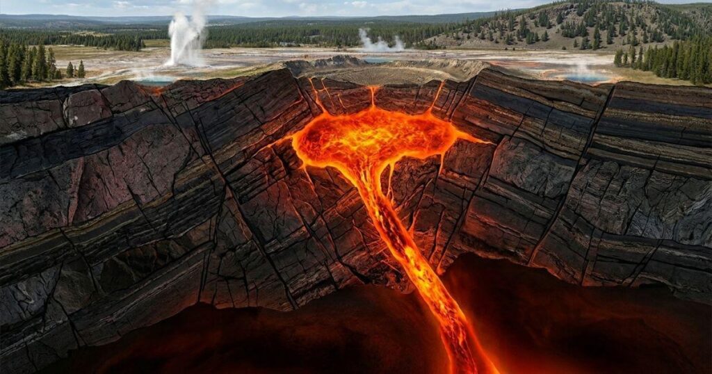
Yellowstone has produced three of the largest volcanic eruptions in Earth’s recorded geological history. The first, the Huckleberry Ridge supereruption, occurred 2.1 million years ago and remains the largest in the complex’s known record. The most recent caldera-forming event, the Lava Creek eruption, struck 630,000 years ago, blanketing vast areas of North America in ash and almost certainly disrupting global climate patterns. The caldera sitting in Yellowstone National Park today is the scar left by that event, a depression roughly 55 by 72 kilometres across. Three eruptions of that scale in 2.1 million years means Yellowstone produces a catastrophic supereruption on an average cycle of roughly 700,000 years. The Lava Creek event is now 630,000 years in the past.
For decades, the prevailing explanation for Yellowstone’s volcanism was a mantle plume: a column of abnormally hot rock rising vertically from near the boundary between Earth’s core and mantle, roughly 2,900 kilometres down, pushing heat upward until it melts rock near the surface. Plumes of this kind drive volcanism at Hawaii and Iceland, and the geological track of ancient eruptions running southwest from Yellowstone through the Snake River Plain in Idaho appeared to support the idea that the North American plate was drifting over a fixed deep heat source. That model has faced increasing challenges from seismic imaging that could not locate a clean, vertically continuous column of slow seismic waves extending from the deep mantle to the surface beneath Yellowstone, and the new three-dimensional modelling now provides a competing mechanical explanation that fits the available data without requiring a deep plume at all.
The system the new model describes is called a translithospheric magma plumbing system, or TLMPS. The lithosphere is the rigid outer shell of Earth, comprising the crust and the uppermost portion of the mantle, and it extends to roughly 70 to 80 kilometres depth beneath the Yellowstone region. Below the lithosphere sits the asthenosphere, a partially molten layer of mantle rock hot enough and soft enough to flow slowly over geological timescales. Melt generated in the asthenosphere at around 90 kilometres depth does not simply rise straight up through the lithosphere to feed Yellowstone’s shallow magma reservoirs, a path of approximately 80 kilometres. Instead, seismic tomography and magnetotelluric imaging, which maps electrical conductivity underground by measuring how natural electromagnetic signals penetrate the rock, show that the melt-bearing zone dips toward the southwest and connects Yellowstone’s shallow crustal reservoirs to the asthenosphere beneath the Eastern Snake River Plain, 150 to 200 kilometres to the southwest. The plumbing is angled, not vertical, and understanding why it is angled is the core question the new model addresses.
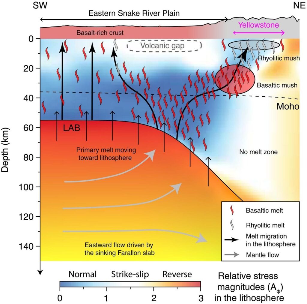
Yellowstone’s present-day translithospheric magma plumbing system (TLMPS).
The answer involves two separate mechanical forces acting simultaneously on the lithosphere. The first is basal traction, which is the drag exerted on the underside of the lithosphere by the asthenosphere flowing beneath it. That asthenospheric flow moves eastward across the region, driven by the subducted Farallon slab, an ancient oceanic plate that was consumed beneath North America millions of years ago but continues to sink slowly through the deep mantle beneath central and eastern North America. Its sinking motion pulls the surrounding mantle material eastward, generating a slow but enormous wind of hot rock flowing beneath the western United States at speeds of roughly 5 centimetres per year. This eastward drag compresses the lithosphere from below, but directly beneath the Eastern Snake River Plain, a corridor of locally heated asthenosphere promotes upward flow that produces extension in the lithospheric mantle above it at depths between roughly 40 and 70 kilometres. Further east, where the lithosphere thickens beneath the Wyoming Plateau, the eastward-flowing mantle material hits this thicker, denser root like a river hitting a dam, generating additional compressional pressure drag against the western edge of that root and producing a stress contrast between the Snake River Plain region and Yellowstone itself.
The second force is lithospheric body force, which is the mechanical consequence of density differences within the lithosphere itself. The crust beneath the Eastern Snake River Plain is unusually dense because it has been repeatedly infiltrated by basaltic magma over millions of years, making it heavier than normal continental crust. Dense material tends to sink, and as the Snake River Plain crust pulls downward, it drags on the surrounding rock and generates extension in the crust nearby, including beneath the Yellowstone caldera. Simultaneously, the deep cratonic root beneath the Wyoming Plateau to the east, a thick keel of cold, dense lithospheric mantle that has survived since the Archean eon, more than 2.5 billion years ago, sinks under its own weight and induces compression in the lithosphere directly above it. Where these two forces, basal traction and body force, nearly cancel each other out, the rock experiences no net extension and no volcanism occurs. That cancellation zone corresponds precisely to a documented volcanic gap in the Eastern Snake River Plain where no eruptions have been recorded in the past 2 million years.
Everywhere else the two forces reinforce extension rather than cancel it, and extension is what allows melt to move. When rock is pulled apart, it fractures, pressure drops locally, and molten material can migrate into the gaps. The model calculates a zone of maximum non-compressive deformation that dips toward the southwest at an angle controlled by the geometry of those two force systems, and that angled zone matches the observed geophysical structure of the TLMPS to a degree the authors describe as closely resembling the seismically imaged system. Of 98 percent of dated volcanic rock samples from the Yellowstone region plotted against the model’s deformation map, all fall above zones of non-compressive middle-to-upper crustal deformation rates above 1 times 10 to the power of minus 16 per second, a threshold that represents the typical value beneath the non-volcanic gap. The geometry of past eruptions traces the geometry of the stress field.
The melt itself originates primarily in the uppermost asthenosphere at roughly 90 kilometres depth, generated not by a plume but by decompression melting as the eastward-flowing hot mantle material encounters the diverging stress field created by the Snake River Plain’s hot asthenospheric corridor. Decompression melting is a process in which rock that is already close to its melting point begins to liquify not because it gets hotter but because pressure decreases around it, lowering the melting threshold. This process generates what geologists call primary mafic melts, which are basaltic liquids rich in magnesium and iron with a composition reflecting the mantle material they came from. These primary basaltic melts enter the tilted plumbing network, migrate northeastward and upward through the lithosphere along the path of maximum extension, and stall in the lower crust beneath Yellowstone at approximately 35 kilometres depth. There, because basaltic melt is denser than the surrounding felsic, or silica-rich, crustal rock, it cannot easily continue rising. It pools and crystallises slowly, forming a long-lived zone of partially molten basaltic mush that seismic tomography identifies as a region of unusually slow seismic wave speeds concentrated beneath the southwestern part of the caldera.
Heat from that basaltic mush is what ultimately drives the eruptions that make Yellowstone famous. As the lower-crustal basaltic mush accumulates over tens of thousands to hundreds of thousands of years, it transfers heat upward into the overlying felsic crust, causing that crust to partially melt and differentiate into rhyolitic magma, which is the highly viscous, silica-saturated liquid responsible for explosive supereruptions. Rhyolitic eruptions are catastrophically more violent than basaltic eruptions because the high silica content makes the melt thick and resistant to degassing: dissolved gases such as water vapour, carbon dioxide, and sulphur dioxide cannot escape gently, so pressure builds until the magma fragments explosively. The model places the rhyolitic mush zone at 8 to 10 kilometres depth directly beneath the Yellowstone caldera, which matches the upper-crustal slow seismic anomaly logged by local seismic tomography. That upper-crustal reservoir currently contains between 10 and 30 percent rhyolitic melt by volume, below the 30 to 50 percent threshold typically required for the system to transition from a partially crystalline mush to a fully eruptible magma chamber.
The current state of Yellowstone’s subsurface is not one of an imminent eruption. The melt fractions in both reservoirs sit below the threshold for full mobility. The lower-crustal basaltic mush carries 2 to 10 percent melt by volume and the upper-crustal rhyolitic mush carries 10 to 30 percent, with both figures falling short of the roughly 30 to 50 percent fraction at which a mush transitions to eruptible magma. The US Geological Survey and the University of Utah Seismograph Stations continue to monitor seismicity, ground deformation via GPS, and hydrothermal activity across the caldera system in real time. No current monitoring data places the system on a trajectory toward eruption.
SOURCE
Cao, Z., Liu, L., Wan, B., Chen, L., & Lundstrom, C. (2026). Tectonic origin of Yellowstone’s translithospheric magma plumbing system. Science, 392(6794), eady2027. DOI: 10.1126/science.ady2027